Sunday, October 16, 2016

Day 13 - Stingray Point (Deltaville) to Portsmouth, VA

0930, after christening one cooktop with scrambled eggs and toast, we pulled out of Dozier's Regatta Point, near the town of Deltaville on Stingray Point and headed south to Mile Zero. 

Thankfully, another day of ideal conditions, with calm seas and wind to frustrate sailors. For us, a beautiful and peaceful run. The only small drawback was that we ran most of the day against the current, on average making less than 9 knots.

Passing Thimble Island Shoal Light

Just huge


So far we have run 735 NM since leaving Maine. A bit more than a third of the trip, (?)


Warming up a bit today

We missed the windjammer race over this past weekend which started in Baltimore (with the Blue Angels performing) and went south to Norfolk. We saw several of them leaving the area.


Heading home
Homeward bound
The Tidewater Yacht Agency is the "go to" spot for provisioning for the inland route. 

In Portsmouth, VA, looking across the Elizabeth River to Norfolk
Here, we'll spend the night and take care of a few "to do's" before heading out for Coinjock.

Tomorrow, we officially enter the ditch. We may go outside here and there, but for the most part, the rest of the trip is on the ICW.
Pre dinner beverage alongside


Saturday, October 15, 2016

Day 12 - St. Michael's to Stingray Point

St. Michael's Marina
We awoke to an amazing (and somewhat cool) morning but the day promised to warm up.  It was flat calm and clear as a bell so we pulled out at 0735 and ate breakfast under way.  Spectacular day on the belly of the Chesapeake.
Sunrise on the Chesapeake-pulling out of St. Michael's
We had no specific destination picked out for today.  People had mentioned Solomons or York but we had to do what the Lady A could do, within reason.  Given the fabulous conditions, we traveled our second longest run today, 95.5 nautical miles.   There is so much we didn't see, taking the rhumb line. The Chesapeake is vast.

Smith Point Lighthouse marking the entrance to the Potomac
One could spend a lifetime exploring the Chesapeake or any of these bays,  shorelines and inlets on the Atlantic coastline and never scratch the surface.  (For that reason, at least John may need to do this again, in years to come.)

We ended up targeting a marina somewhere on Stingray Point on the eastern shore, Virginia, simply because that area was more than halfway to tomorrow's destination.  I love random stops.  That's what makes a trip like this.

A little exercise,
stretching and balancing, underway.
So we were able to take advantage of today's great weather and have an easier run tomorrow, in order to arrive in Portsmouth, VA with some decent time ashore.  Portsmouth is Mile Zero of the ICW.

As mentioned, we motored 95.5 nm for 8 hours, 45 minutes today.  This all may sound so glamorous but much of it is pretty boring. We may start playing gin rummy or Jotto soon. (Perhaps we all need to do more stuff like that!?)

Nap Time
Today, we ended up in Dozier's Marina, which is fantastic.  Friendly, conveniently located from the Bay, clean facilities and they host the Virginia Yacht Club.  It's on Stingray Point near the town of Deltaville.
Dozier's
They're having their 3 day, end-of-year party/annual meeting, during which lots of boisterous proposals were being "Aye, Ayed!", well into the evening.  We grilled our ribs at their fine facility while trying not to listen to the proceedings.
Annual Closing Ceremonies of the Virginian Yacht Club
On to Portsmouth, Mile Zero, tomorrow.

At rest alongside
,


Friday, October 14, 2016

Day 11 - Bohemia River to St. Michael's

BBYH


Another beautiful day on our trip, awakening at the Bohemia Bay Yacht Harbour, right where the Bohemia River feeds in to the Elk River, an estuary at the head of the Chesapeake Bay.
Northbound


We had fair seas and skies all day and luckily were running with the wind and current most of the day.  The intended destination was St. Michael's, a remarkable town of nautical interest on the eastern shore of Maryland, which we plotted to be about an eight hour voyage.


Infrastructure barging north


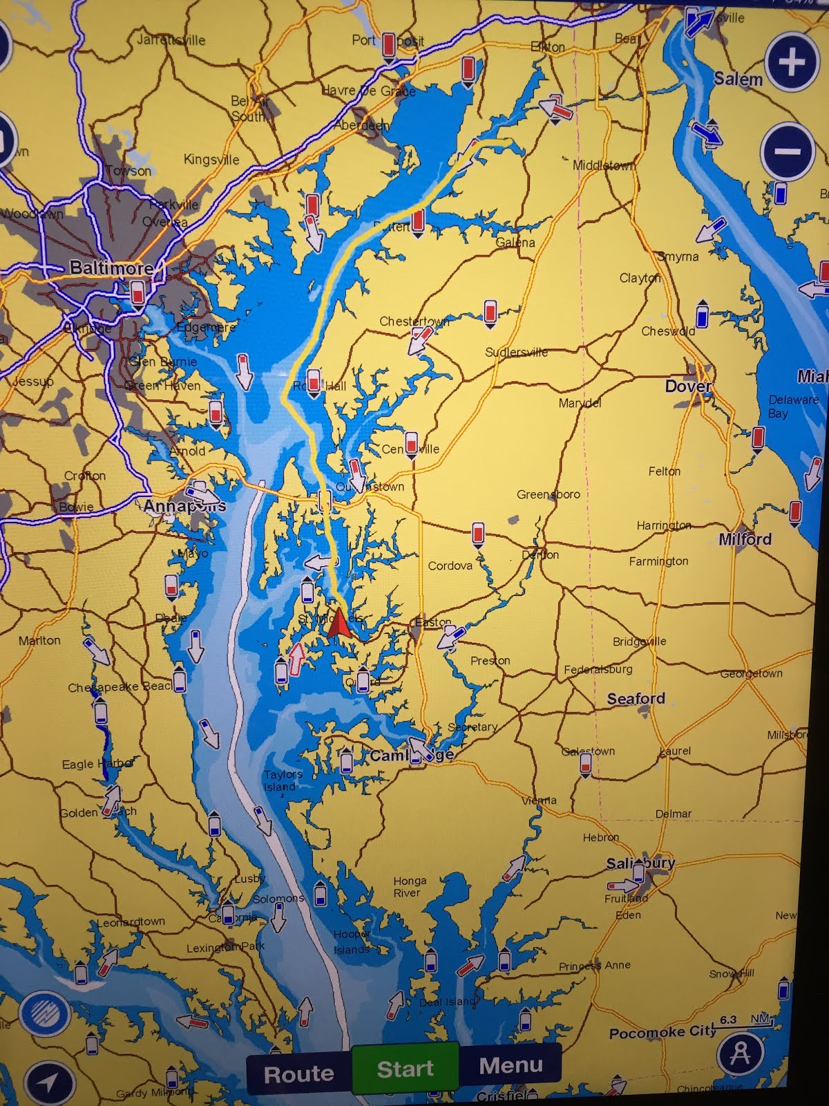
After exploring the charts a bit more, we discovered an "inside route" that went through the Kent Narrows.  It required passing through a no wake zone for a bit but shortened the trip by about two hours.  This was a pleasant surprise as we'd been running long and hard for the past few days.


The inside route, 10-15 miles shorter?

Benefits of the auto pilot - from the foredeck

Almost everywhere we end up, people stop by and want to know about the Lady A and her story.  (Amanda is tired of it but John is happy to tell the tale.) In St. Michael's, a gentleman walked up and said, "Are you from Chebeague?" to which Amanda said, "Yes".  He said, "Are you Mrs. Layng?" Oh boy! Turns out, Will Langan (sp?) introduces himself- a Cliff Island guy who had worked at the Chebeague Island Boat Yard from 2008 to 2012!  Knew all about our boat. Small world!  The next guy that pulled in to St. Michael's was Alden Colby, a captain from downeast who's been to Chebeague, he and I had met briefly and, again, he recognized the Lady A. Double small world in the same marina, the same night!
Prime Location-on the inside
British flags are flown prominently here because of the way the citizen's faked out the British so well during the War of Independence (I think we called it the "Revolutionary War" growing up.?).


Exploring town

Christ (Episcopal) Church

St. Michael's is an historic town, with a great feel, worth seeing and exploring.  We wish we could stay longer but.....God willing, we'll be back.
This evening, we met up again with our new friends for dinner (Limoncello), loads of fun, and they will now run point on our journey south, due to their much swifter vessel. Thanks, John!

Thursday, October 13, 2016

Day Ten-Cape May Canal to Delaware Bay, north to C & D Canal

We awoke to a fabulous day after a much needed good night's sleep for both of us. Great gunk hole.
South Jersey Marina is on a favorite list.
Pulling out of South Jersey Marina
Calm waters clear skies
Once again, we were very lucky with the weather and Delaware Bay, for a long (60NM?) northern run against the current, was flat calm.  Another very shallow bay, shoaling to 5 feet (or less) in spots.


Delaware Bay doesn't seem to offer much in the way of "attractions" although I am sure there are many.


Clouding up a bit


Delivery made


Salem Reactor


Against the current, again, we went through the 14 mile Chesapeake & Delaware Canal that cuts west to the top of the Chesapeake Bay,  Elk River, actually.

 (Question: "If  Pennsylvania  married New York, what would Delaware?  Her New Jersey?  Idaho. Alaska.")

A pretty long day covering 73.2 nm in 7.3 hrs.


Just outside the Canal, to the east, is a small river called Bohemia.  We found this peaceful, idyllic place called Bohemia Bay Yacht Harbour.  Sooooo quiet which is much welcomed.  Unbelievably peaceful.  Dinner aboard tonight listening to John Prine.
Moonrise not captured (Need my selfie stick!)


On Maryland's Eastern Shore


Note the moonrise just over the trees

1826 (sunset)

Wednesday, October 12, 2016

Day Nine - Barnegat Light to Cape May, NJ


We spent last night next to the Coast Guard Station in Barnegat Light.  Very cool because cadets were being trained for evening maneuvers.  However, very bad for sleeping! Between the night rescue maneuvers, the working fishermen up before dawn starting engines and Amanda not feeling well, not much sleep was had. A has a bad cold with cough. Bummer!


Took an early morning walk to the Inlet Deli to get coffee and a paper, breakfast aboard and then shoved off at 0835.


Quiet Atlantic off Atlantic City
The run from Barnegat to Cape May was another all outside day, and thankfully, uneventful and somewhat boring..... but all you can ask for due to light winds and calm seas.  The Jersey Shore has beaches that go on and on and on.


For those of you who care, we covered 69 nautical miles today in 5.9 hours, averaging about 11 knots (burning 7.3 gal/hr), a comfortable day.


South Jersey Marina is a very nice facility. Fantastic showers and chandlery   Friendly folks.  Drove us downtown Cape May and we hiked back.

Cape May is known, historically as the Jersey Shore's first summer seaside resort town in the early 1800's.  We checked out the outdoor mall, the restored (and unrestored) famous Victorian houses, hotels, and boarding houses.
Colonial Hotel, water views from the back (front?) side


Amanda ate take-out for dinner so she could lay low while John dined at Lucky Bones with new friends who are doing the same trip (but to the east coast of FL). Comparing notes!


We have decided to take the northern route up Delaware Bay, across the canal and then down the Chesapeake, then on to Portsmouth. We're here.....
(photos and edits to come)

(

Tuesday, October 11, 2016

Day Eight -Rowayton, CT to Barnegat Light, NJ

Due to gale warnings and hurricane paths being determined, we opted to wait in Connecticut for a while and are thankful we could be berthed these last 16 days, in Rowayton, CT.

Hurricanes Matthew and Nicole have ceased dancing in the Atlantic, for now. (Nicole is still there...)  

So, on an ideal day we left at 0730,  very little wind and  calm seas all the way to the Narrows. 


Execution Rock
Approaching Hell Gate


We caught the tide and current just right as Long Island sound  narrows and swiftly went through Hell Gate and down the East River with abandon. 


Swift and swirling East River


MANHATTAN looked spectacular!  


Security seemed high still as there were no fewer than 8-10 government vessels wanting to know your purpose. 


Bridges galore.

Throgs Neck
Whitestone

Manhattan

Train bridge with Triboro (RFK) behind
The Battery
Lady Liberty


Verazzano


Not a cloud until the afternoon. 


A little choppy on outer NY Harbor and we got sprayed on 
a bit getting out beyond Sandy Hook but , overall it was relatively clear sailing all the way (4 + hrs) to Barnegat Light. With an east-north-easterly sea, we motored 1-3 miles off shore in 25-35 feet of water.

Our longest run yet today, 97NM in 8:28.


We are nestled in a commercial fishing marina on a barrier reef. Very appropriate.  Not much bait smell. There's a fabulous island flavor here and a restaurant to go with it.  A must do when alongside at Barnegat Light Marina: go to the down home, Kubel's Bar (est. 1927) for a meal. Fabulous (and renowned) garlic clams!

Pre-sundown at Barnegat Light Marina
(Should be painted!)
Probably destined for Cape May tomorrow and then decide whether or not to go outside, right to Norfolk, or to go north, up Delaware Bay and take the canal over to the Chesapeake and down.  Decisions, decisions.

Monday, October 10, 2016

Planned and Unplanned Layover

October 10th, 2016
Many people have been wondering where we've been and what's going on so, thank you for your interest and here's an update.
Five Mile River
First of all, for the past two weeks +, the Lady A has been snug in her berth, at a friend's slip in Rowayton, CT, up the Five Mile River.

Having arrived in Rowayton on Sep 22nd as planned, the next leg was to have embarked Sep 27, with a friend taking Amanda's place for the four day run down to the Norfolk, VA area. The goal was to get the Lady A to Portsmouth, VA, which is Mile Zero of the ICW. where she'd stay for 10 days or so.  I had planned to fly back to CT for some meetings and then Amanda and I would go to Maine to close up for the season and retrieve our car.

Well, Gale Warnings deterred that plan.  There were 30 knot winds and 15 ft seas off of New York Harbor that day and the next.  Immediately following that, Hurricane Matthew and his lady friend, Nicole, were stirring it up in the Atlantic.


This made us very glad we didn't have the boat already in the Virginia area!

Anyhow, the plan now is for Amanda to join John for this next leg, to shove off tomorrow morning, October 11 and take 3-4 weeks, weather permitting, for the voyage to Florida.

Again, no promises, but I'll try to continue this blog!

Wish us luck!