Monday, October 31, 2016

Day 28 - Titusville to Vero Beach

October 31, Halloween

We shoved off relatively early, just after 0800. 

Titusville Sunrise
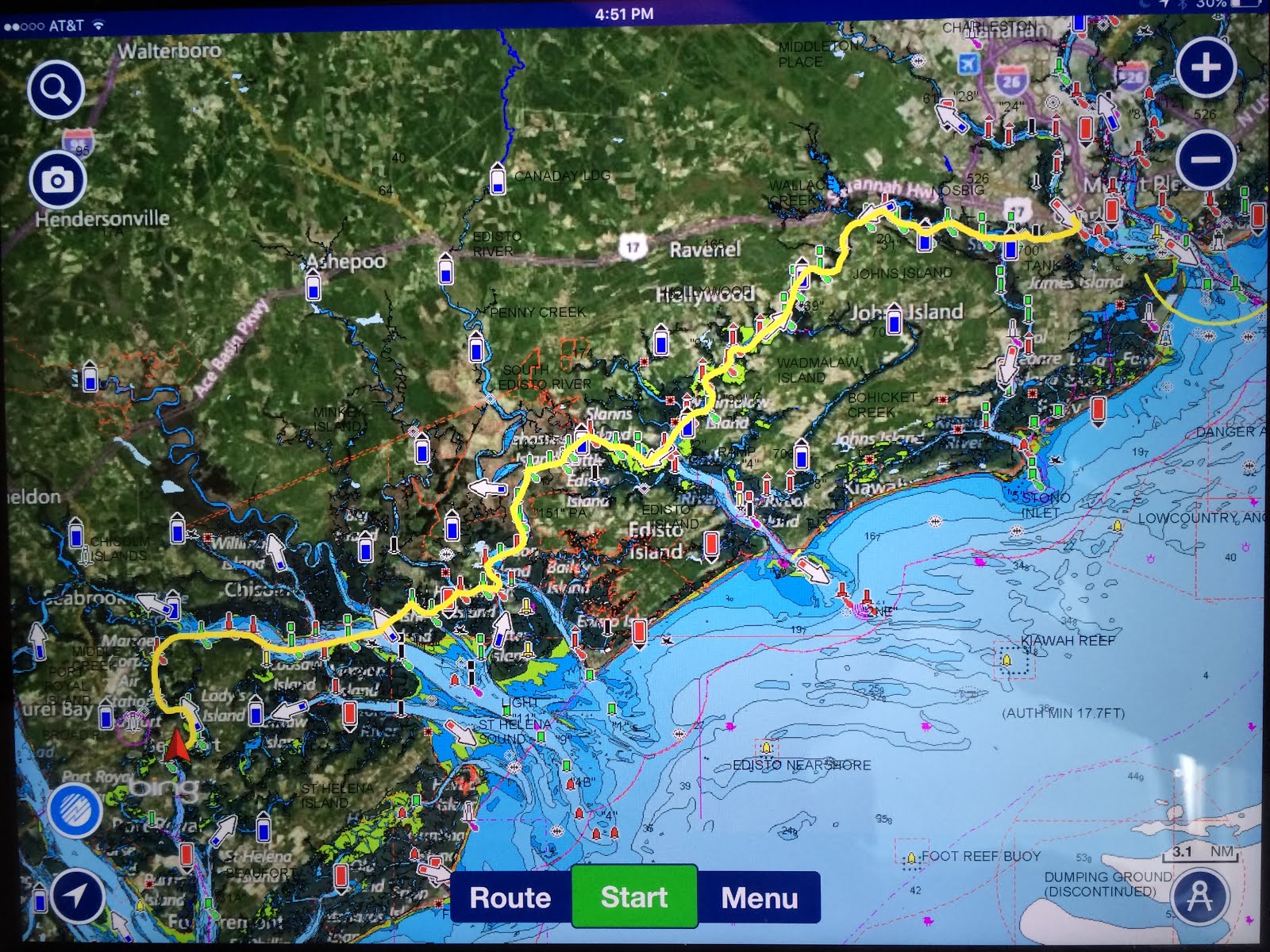
Today's float plan is very straightforward, due South down the Indian River. It was another beautiful day to be on the water but a somewhat boring run due to it being a straight shot, "in the ditch" on the well-marked ICW. 

Leaving Titusville, we passed Port St. John, Cape Canaveral, Melbourne, Sebastian and then down to Vero Beach. 


After about five and a half hours, we were getting pretty bored.  
Well, just near Sebastian, we spotted a school of dolphins ahead. The first mate got her camera ready as we approached them. We'd seen so many by now but these guys looked like a school of aggressive playmates. Well, they gave us quite a show. 
Darting to port

Diving under the stern

For several minutes they were dancing, twirling and frolicking in our wake. Darting under the boat, then backing off in order to dart into the back thrust  once again. Something about the sound of the engine combined with the wooden resonator?

Literally within just a few feet of the boat.  

VERY exciting. Dolphin obviously like swimming at about a 10 knot pace. 


Darting to starboard

We got to Vero with enough time for some real exercise, a brisk walk around town and back in time to freshen up before dinner.

Tomorrow's plan is to get to the Stuart area, a convenient stop before the beginning of the Okeechobee Waterway. which takes us over to the west coast, exiting into the Gulf of Mexico in Ft. Myers, just north of Naples.

Sunday, October 30, 2016

Day 27 - Palm Coast to Titusville, FL

October 30.

Shoved off early as this marina did not offer much in the way of sustenance. Just a cup of  hot coffee.  We decided to sleep in since our float plan was relatively short.  The only thing was, we didn’t account for "'slow", "no wake" and "idle speed only" zones for several sections of the run.  

Hound dog, sit down, stand up paddleboard
Had to request a bridge opening, now and again.
Yes sir! Please open the Bulow bascule bridge!
Ponce de Leon Inlet Light


Tons of boating activity through the South Daytona area, around the Ponce de Leon inlet area and just south in New Smyrna.
Dolphins abound: We took so many bad shots, this one's "okay".


The challenge was to scout ahead, look at signs with binoculars and pay attention to any and all signs.  Needless to say, it’s possible to miss one, now and again.  Anyway, we had an unscheduled delay while a coastal law enforcement officer checked out the Lady A and her credentials.  Some areas are "slow manatee" areas and then there's the newly damaged coastline. The hurricane damage has made all waterfront property owners and their agents, understandably, hyper-sensitive. We felt it was all but certain that a summons was going to be issued. But fortunately the officer came back with only a warning, verbally recognizing the " pedigree," of the boat.  Thus, we got a warning and were essentially granted a pardon. Pure speculation but he told us the property owners want tickets issued.


Then we had a long stretch through Mosquito Lagoon into the Cape Canaveral area, pulling in to Titusville for the evening. 

NASA bascule bridge on way into Titusville


One of our least productive days, from a time spent per nautical mile, 69 nautical miles in 7h 50m.

A must-do burger joint for tonight, Quam’s.  Worth two Absorbaid and one Pepcid AC.

Day 26 -October 29 - Amelia Island Yacht Basin to Palm Coast, FL

We fueled up first thing in the morning and shoved off about 0900.
Just out in the ICW, we had to go through a bascule train bridge and under a car bridge.
Just outside Amelia Island Yacht Basin


Air boat

Once in Florida, the ICW becomes a little more interesting and scenic than in Georgia and parts of SC, some of it because it offers a variety of naturalist topography and some for the human creations, houses, dockside toys and boats.

That said, the ICW is more of a straight shot and narrow so there is less variance in the route you can take. 
Approaching St. Augustine

An exception was in St. Augustine's Sound, a bustling area with lots of boating activity.

St. Augustine's city front


Large sailing vessel, Tabasco, that we had seen in Newport
earlier on our voyage crossing the draw bridge in St. Augustine's

One area, however was very tricky, taking you close to shore for an illogical route, as the center of the channel was shallow from shoaling.  As we approached, there were two vessels already aground and one shot out a warning to us over the VHF to get over closer to shore.  Good thing, as despite reading about the warnings in our Waterway Guide guide, we were headed for the area where we might have grounded out. 

Grounded vessels

Hopefully these vessels just needed to await the incoming tide before moving on and sustained no damage to their props, shafts or hulls.

Wave runners

One part of the run of severely storm-damaged waterfront structures had an emergency “No Wake” zone. We were warned of this by a patrolling law enforcement vessel’s officers.


More hurricane damage

We made our way into the marina at Palm Coast for the evening.  A fun condo complex nearby had a fun plaza inside the complex, a "European Village" with lots of activity, eight restaurants, live music and folks dressed up in their Halloween costumes.  We closed the evening with a few games of gin.  We won't say who won the most hands.

Saturday, October 29, 2016

Day 25 - St. Simon's GA to Amelia Island Yacht Basin FL

Day 25-Oct 28

Checked out the town of St Simon's last evening and dined at the Georgia Sea Grill. Easy Uber, to and from. 

We have planned only a short run and given tidal issues, we did not have to leave before mid-day. Shoved off a little after 1200 and headed across St. Simon's Sound to the ICW adjacent to Jekyll Island. Here we saw the first pink flamingos of the trip. 

After that we had to cross St. Andrew's Sound. This one was exciting as parts were only 5 feet deep and just a little wind created some nice chop just as Amanda was making lunch for us. 
Then we traveled along the ICW adjacent to Cumberland Island, the last spot along the Georgia coast. 

By the way, we are in the area during a huge collegiate game tomorrow, Georgia vs Florida. Lots of people in town wearing  team jerseys for this one.

Fort Clinch

Industry in northern Florida
We enjoyed navigating down the Cumberland River at a leisurely pace and crossed the border into Florida and found refuge in a marina still standing, the Amelia Island Yacht Basin for the evening. 


Sunset at AIYB


Day 24-Thunderbolt to St. Simon's Island, GA

Oct 27 - Thunderbolt to St. Simon’s Island, GA
Another of Amanda's

Heart stopping goodness

Thunderbolt Marina had a special treat of Krispy Kreme donuts and coffee to welcome the day. (0700)

Headed down the Savannah River into the Skidaway River, through the Narrows ands toss the front of Moon River, (yes, the Johnny Mercer song that Andy Williams made famous) into the Vernon River. Down the Vernon toward Ossabaw Sound, through Hell's Gate and up the Ogeecheer River, through the Florida Passage into the Bear River. Made good time with the current down the Bear. 

Another Trumpe

Across St.Catherine's Sound over to and down Johnson Creek into Sapelo Sound. 

Up the Sapelo River into the Front River. Buttermilk Sound to the Mackay River. We considered doing the Frederica River which parallels, but the tide was going and it’s a bit tricky. Exited the Mackay near Lanier Is which we rounded and headed back north due to an impassable bridge.

There has been shoaling going on, a large part due to Hurricane Matthew.We have had a couple of bumps here and there but knock wood, so far, so good.This was a long day of 8h35m traveling 82.7nm.


Morningstar at Golden Isles was our marina and it's pretty large with many good size yachts.
We borrowed the courtesy car for a quick tour of St. Simon's. Dinner via Ubers at Georgia Sea Grill.


Wednesday, October 26, 2016

Day 23 - Beaufort SC to Savannah (Thunderbolt) GA

Border crossing day.

Breakfast joint, Blackstone has prep school banners, including Blair...
...and Foxcroft!


Leaving the Beaufort City Front
October 26
Shoved off at 0930 
We have a short (and windy) float plan of about 50 nm for today to go visit some friends from Chebeague and have dinner at their home (for a nice change) near Savannah.


We first ran down the Beaufort River. Running with the current, we made over 10 knots at only 1700 rpm for several miles, a fuel-saving run. 

Went across Port Royal sound and across the Chechesee River, we made our way in to Skull Creek, just on the north and west side of Hilton Head. Skull Creek empties into the Calibogue, across the front of the May River, where we traveled down into the Calibogue Sound and over into the Cooper River. 

Then through Falls Cut into the Wright River, going north and finally through Fields Cut leading into the Savannah River. Then across the Elba Island Cut into the Wilmington River. Thank the Lord for the Army Corps of Engineers!


Our home for the night is Thunderbolt Marine which is a serious boat yard with a marina. We had a fun, relaxing evening at a lovely home ashore on Skitaway Island.

We have an early departure planned as we'd like to make it to Jekyl Island tomorrow on the inside route.  We'll shove off just after the krispy kreme donuts are delivered!

Day 22 - Oct 25 - Lay Day in Beaufort, SC

We decided to stay in Beaufort for a day and play golf.  But in the meantime, we thought we'd take a look at the overall chart to gain some perspective of how far we have come, to date.

Highlight indicates areas where charts have been downloaded

Pretty far.  Certainly more than halfway to our goal.

Beaufort History

After the local yoga class we had a leisurely breakfast and got ready for a day of golf. 


A friend had arranged for us to play Secession, a very special course right across the harbor from Beaufort. A fun break from boating day after day. 

Arriving at Secession


#18 tee with #17 green behind
(including a bit of hurricane damage)

A fun evening out at a local favorite for dinner, Breakwaters.

Monday, October 24, 2016

Day 21 - Charleston to Beaufort, SC

After a full breakfast aboard, we shoved off from the Charleston City Marina and crossed the Ashley River a short spurt into the ICW and headed west through the Elliott Cut and up the Stono River. The Stono River runs alongside John's Island, home of Kiawah which got hit pretty hard by Matthew. 

But first, we forgot to mention the amusing names of the pump out boats the City Marina deployed, "Bow Movement" and the "Grateful Head".


Pump out boat
Clever

This day offers a ride which traverses rivers, creeks and cuts, winding west, south and even north from time to time. 

Then up the Dawho River over North Creek and into the South Edisto River to run south. 

The goal is to get to Beaufort by mid afternoon so we can explore this historic town. 

60 windy nautical miles

Then through the Fenwick Cut up the Ashepoo River, then a cut over and up Rock Creek, and then one final cut for the day into the Coosaw River leading up to just north of Beaufort, into it's river and down to town. Phew!

More info than you care to know. 


Beaufort is a special place yet we need to explore more.   
A rare "Angel Live Oak"
branches touch earth and rise again

That said, we've already taken a carriage tour and grabbed tons of history. 


The architecture in Beaufort dates back to the 1700's though much was destroyed in 1907 in a great fire.  But the primary reason we get to see these beautiful homes is that Beaufort fell to the Union only six months after the Civil War started and was in possession by the Union the duration of the war. All the citizen's left, thinking they'd be hanged. Historians postulate the if the "scattered" had resisted, the city may well have been burned to the ground by the Union Army.


The Castle
Rice, Indigo, lumber, fishing all drove this economy, in the day. Now military and tourism as well.
The Beaufort Mermaid


One of the great things about boating is you have waterfront property every night!

Day 20, Lay Day in Charleston

Sunday, October 23, 2016
Charleston - Lay day. A well deserved break from the typical six to nine hours of driving a boat into the sun. 


Her resting place.......

Got a lift into the center of town, the French Quarter, and had a great brunch at Rue de Jean. 


We then explored pretty much the entire city on foot. Quite pedestrian friendly, Charleston has such a rich history and interesting and attractive architecture. We started out in the Visitor Center, of all places, and then went to a Fort Sumter exhibit.


We even spent an hour taking a guided tour of the Edmondston-Alston House, almost entirely preserved architecture, art and artifacts from the Antebellum period. Very interesting. 


Sunday, October 23, 2016

Day 19 - October 22, 2016 - Georgetown to Charleston, SC

0900 shoved off from Georgetown and decided to go north around the harbor island to check out the paper and steel mills. 


International Paper - at one time the largest paper mil in the world
Industrious Georgetown

We were supposedly in a dredged channel.  Well, as we were navigating around some hurricane debris, the depth finder indicated that we were rapidly losing water under the Lady A. The ability to turn diminished quickly and the depth finder indicated zero  We were running aground but were able to reverse rapidly and pull ourselves off of the muddy bottom. Needless to say, we reversed our direction and went back the way we came-an exciting beginning of the day!


Fortunately the rest of the day was uneventful, six hours of navigating down the Intracoastal Waterway, 60 nautical miles.  We first went down the Waccawaw River with the current a few miles, and then into the ditch pretty much for the rest of the day.  Went past Cat Island, Crow, Cedar, Murphy, then just before Charleston Harbor we passed by Pine Island and Isle of Palms.  Quite nice homes all along this part of the waterway.
Isle of Palms

We landed in Charleston Harbor with tons going on this Saturday afternoon:  so much water activity with ferries, tour boats, large sailing yachts and a large small sailboat regatta.  Pretty good wind, too, out of the Northwest.

Charleston Yacht Club race
Arthur Ravenele Jr Bridge

We fueled up at the Charleston City Marina and were given directions to our slip, necessary since this is the largest marina, the most dock frontage, perhaps on the entire eastern seaboard.  It’s so large that the staff gets around in golf carts and many boaters keep bicycles at their slip to ride up the various fingers!

John's next yacht


We have decided to take a lay day here on Sunday to relax and explore the city.  A much needed, and deserved, resting day.